PICAXE is in Space

Paix

Senior Member
CORRECTION I previously said spacetrack.org, but was wrong, it is space-track.org

If posting TLE or 3LE (TLE with satellite title line) can I advise enclosing it in CODE tags as browsers are likely to remove formatting spaces to single spaces. programmes that use TLEs depend on the placement of data within defined character fields in each line.

@Srnet, Are you still using a current "UNISAT 5" TLE for your tracking ( Norad catalogue 39421U )? Note that space-track defines it "UNISAT 5" whilst elsewhere "UNISAT-5" seems prevalent and if ever searching for birds with a hyphenated name, without any luck, then trying it spaced (or vice versa) may restore sanity . . .

I can recommend signing up as there is a lot of info to be had there.

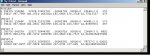
I looked up the satcat (satellite catalogue) specifying launches on 2013-11-21 (21 November 2013) and then clicked on the NORAD catalogue number to sort it. It returned only nineteen objects, two of which were DEBRIS and a significant gap in the sequential catalogue numbers. As you have mentioned previously, size does matter . . . this may be down to reasons of National Security, inability to track due to size and a few other reasons. Given that neither EAGLE2 or more than a couple of birds involved in the launches on that date were anything to keep schtum about, then either they haven't been reliably tracked yet or may not be. Fingers crossed. That's why I harp on about the NORAD catalogue number so much, it's unique and definitive and unlikely to be mangled. :)

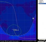
The hole in the NORAD sequence ( 39432 to 39447 ) indicates that there are packages under a security blanket or yet to produce reliable tracking data. The last items catalogued are the rocket body and debris. These last details are published once the number of items to be tracked has been ascertained by the sensor networks.
 

eclectic

Moderator
It might be time for the experts
to give us a guide to:

1. What program to download.

2. The best up-to-date TLE.

3. How to insert the TLE into the software.

4. How to view the pretty pictures.

e
 

MPep

Senior Member
@Mpep, source of TLE is spacetrack.org a USAF facility in New York. sign up for an account, but be aware that they work office hours, so if you have a password problem on a weekend then you will maybe have to wait until Monday morning for a reply.

A few years ago TLE info to Celestrak dried up for a while due to regulatory changes. It's been good again for several years, but the source is spacetrack.org. Take your pick basically whichever is easiest.

How do you find your TLE, get a whole bunch and search for the Norad catalogue number of the satellite. As SRNET has said, these get allocated when the tracking has positively identified the separate entities deployed from the launch vehicle.
Here is a breakdown of the TLE format. Sometimes a satellite may have different names, ie: Delfi-3A DO-64 if in doubt, find the Norad catalog/satellite number from line 1 field 2 and search for that data in a mass download if necessary. Edit and pop the ones you are interested into a file and point Orbitron at it. Not the best way perhaps, but sometimes the categorisation is difficult to ascertain.

Hand held FM transceivers by definition have a weak front end and will easily be swamped/overloaded by close by strong frequencies if using an external antenna that is well up in the clear or a high gain antenna. They aren't designed for it.
Thanks Paix.
Have now signed up. Will probably have to wait as Orbitron cannot connect at the moment.
Interesting site. Will keep looking.
Might see about getting a RT programmed with the right frequency to listen in. :D
 

StigOfTheDump

Senior Member
Will probably have to wait as Orbitron cannot connect at the moment.
Interesting site.:D
I opened aTLE with notepad from the orbitron program folders, renamed it as My-TLE then copied in the UNISAT 3 data from space-track, and also the TLE from post#62, Then I padded out the TLE from post#62 with spaces to get all the decimal points lined up, rubbed out all the others and saved it. Then I loaded it with 'Load TLE' in orbitron.

Using the backward feature in the prediction set up it passed Reading about 11:20 this morning.
 
Last edited:

manuka

Senior Member
Code:
UNISAT-5
1 10000U 13325.30958333 .00066391 00000-0 78737-2 0 00001
2 10000 097.8055 037.9628 0031909 207.6761 327.4099 14.84238859000010
Code:
AO-51                   
1 28375U 04025K   05249.19049334  .00000033  00000-0  23171-4 0  3357
2 28375  98.2097 308.5114 0084740 347.0069  12.8946 14.40476350 62277
Good man- there certainly was/is something wonky in the initial post #62 TLE (above). Aside from spacing the decimal point after the Line 1 International Designator seems suspect - is that "0" before the "097" allowed?

I've shown a known good TLE -refer here for TLE insights.

Rather than wrestle with the numerals,perhaps you can do us a favour & post your tweaked (& apparently now working) TLE for us to ponder. It's high summer here in NZ, but I'll step out into the fierce sun & set my Baofeng to 437.505 MHz if predicted paths are suitable. Stan - Wellington, NZ
 

StigOfTheDump

Senior Member
This is what I loaded

my_TLE.JPG

Code:
FunCube
1 39417U 13066B   13328.52822701  .00004709  00000-0  65186-3 0   152
2 39417 097.7995 041.0710 0063010 185.6906 174.3718 14.77115537   473

UNISAT 5
1 39421U 13066F   13328.51332398  .00003348  00000-0  40481-3 0   175
2 39421 097.8049 041.0921 0032995 196.4231 163.5917 14.83987871   467
                
UNISAT 3
1 28373U 04025H   13327.92444382  .00000716  00000-0  21468-3 0  6801
2 28373 098.1762 284.5450 0069789 203.9839 191.7527 14.44282064495981

UNISAT-5
1 10000U          13325.30958333  .00066391  00000-0  78737-2 0 00001
2 10000 097.8055 037.9628 0031909 207.6761 327.409  14.84238859000010
 
Last edited:

Paix

Senior Member
TLE UNISAT 5 - Norad sat cat 39421 and predictions 25 - 27 November 2013

Thanks for the prompt Stig you are on the ball. Unfortunately Wine buries stuff well down the directory tree, I have myself getting sorted here now.

I have disregarded some passes which are less than 6 degrees above the horizon and marked the more interesting ones for you, but it seems that over the next few days that daylight passes are few and far between. Orbitron will produce single line outputs for passes, but the three lines show AOS (acquisition), overhead and LOS (loss) data for each pass.

For the interest of those that don't know, an orbital period of around 90 minutes is par for the course and six passes per day, but of those usually three can be categorised as very poor and three worth your attention. The following would have fitted this pattern except an ealy 17.xxhrs pass was below my elevation of interest.


Code:
UNISAT 5
1 39421U 13066F   13328.51332398  .00003348  00000-0  40481-3 0   175
2 39421 097.8049 041.0921 0032995 196.4231 163.5917 14.83987871   467
This matches Sunday 24 Nov 11:18 and 22:15 predictions over the UK. The satellite name and NORAD catalogue number match and this was the latest TLE
taken from space-track earlier this evening.

Code:
Search period : 25/11/2013 02:02:03 - 3 days
                28/11/2013 02:02:03
Conditions    : Maximum sun elevation = 0 deg
                Minimum sat elevation = 6 deg
                Illumination NOT required

Time                Satellite              Azm  Elv  Mag Range S.Azm S.Elv
--------------------------------------------------------------------------
25/11/2013 20:51:43 UNISAT 5             126.0  6.0  ecl  2354 294.0 -42.8
25/11/2013 20:56:22 UNISAT 5              62.8 27.7  ecl  1207 295.2 -43.4
25/11/2013 21:01:00 UNISAT 5             359.7  6.0  ecl  2346 296.4 -44.0

25/11/2013 22:27:13 UNISAT 5             186.1  6.1  ecl  2348 323.3 -54.1
25/11/2013 22:32:16 UNISAT 5             261.8 43.4  ecl   891 325.1 -54.6 [COLOR="#FF0000"]**[/COLOR]
25/11/2013 22:37:19 UNISAT 5             337.6  6.0  ecl  2347 327.0 -55.0

26/11/2013 19:36:11 UNISAT 5              62.0  6.0  ecl  2352 276.4 -31.8
26/11/2013 19:37:36 UNISAT 5              46.0  7.0  ecl  2269 276.7 -32.0
26/11/2013 19:39:01 UNISAT 5              30.0  6.0  ecl  2347 277.0 -32.2

26/11/2013 21:07:36 UNISAT 5             136.3  6.0  ecl  2350 297.9 -45.0
26/11/2013 21:12:30 UNISAT 5              66.1 37.0  ecl   993 299.2 -45.7 [COLOR="#FF0000"]**[/COLOR]
26/11/2013 21:17:23 UNISAT 5             356.0  6.0  ecl  2342 300.6 -46.3

26/11/2013 22:43:47 UNISAT 5             196.9  6.1  ecl  2347 329.3 -55.7
26/11/2013 22:48:36 UNISAT 5             264.8 31.3  ecl  1112 331.2 -56.1 [COLOR="#FF0000"]**[/COLOR]
26/11/2013 22:53:26 UNISAT 5             333.1  6.0  ecl  2346 333.1 -56.4

27/11/2013 19:50:59 UNISAT 5              79.6  6.0  ecl  2350 279.4 -34.1
27/11/2013 19:53:34 UNISAT 5              49.5  9.5  ecl  2064 279.9 -34.5
27/11/2013 19:56:08 UNISAT 5              19.4  6.0  ecl  2342 280.5 -34.9

27/11/2013 21:23:35 UNISAT 5             146.4  6.0  ecl  2348 302.1 -47.3
27/11/2013 21:28:40 UNISAT 5              69.1 50.6  ecl   805 303.6 -47.9 [COLOR="#FF0000"]**[/COLOR]
27/11/2013 21:33:43 UNISAT 5             352.3  6.1  ecl  2338 305.1 -48.5

27/11/2013 23:00:30 UNISAT 5             208.4  6.1  ecl  2345 335.8 -57.0
27/11/2013 23:04:59 UNISAT 5             268.2 22.9  ecl  1360 337.6 -57.3 [COLOR="#FF0000"]**[/COLOR]
27/11/2013 23:09:28 UNISAT 5             328.1  6.0  ecl  2345 339.5 -57.5
 

srnet

Senior Member
Latest TLE and 5 day orbit predictions are at the Dropbox location mentioned in post #1, these will be updated as and when I get better information.

Also published is the PICAXE flight software, ground station receiver software and the processor & radio board PCB designs.
 

geoff07

Senior Member
Brilliant effort from all concerned!

If you are running Linux, just install gpredict and update the Kepler Elements from the internet. UNISAT-5 will be there.

At this moment it is about 1800km ENE travelling at 7.5km/sec.
 

srnet

Senior Member
Using $50SAT as a marker to ensure I had the doppler right, I just listened for WREN (437.405Mhz).

WREN was behind $50SAT in the same MRFOD launch tube as $50SAT.

WREN is 2"x2"x2", $50SAT is 2"x2"x3" and 206g.

Pass was 14degrees elevation and 1700km range, $50SAT clearly heard, nothing heard of WREN.
 

manuka

Senior Member
Sorry I'd not the same $50Sat monitoring joy "down under"! What receiver set & antenna did you use ?

My attempts to catch the $50sat beacon were frustrated by an attenuating drizzle that set in. A promising pre midnight pass gave no joy at 437.505 MHz on a Baofeng UV-5R & rubber duckie,in spite of a good 30 mins "squelch open" listen outdoors.
 

Attachments

srnet

Senior Member
I am using a Funcube dongle, a home brew quadrafilar helix made from plastic plumbing pipe, sticks and wire coathanger, plus a SP7000 low noise amp.

Picture at post #41
 
Last edited:

srnet

Senior Member
We are continuing to get good data from $50SAT, and we have some reports from the Southern Hemisphere (Argentina) which show the solar panels charging well.

It will be some time before we can identify from the radar tracks which object is $50SAT, assuming its one of the tracked objects in the first place.

With so may satellites released at once, plus some bits of debris, even after a week the objects may only be 175 miles apart. At that distance its still difficult to say if reception reports match the timings given by a set of orbit parameters.
 

manuka

Senior Member
Glad to hear this - we've high season sun at present down under of course. I've just tried another late night listen (~midnight local NZ time), but to no avail. It should have been doable as I'd set up a decent Yagi, but I'd only been 10 minutes monitoring before being side tracked by matters terrestrial- scurrying penguins no less! Talk about a come down after looking skywards.

Our (protected) Little Blue Penguins are only cat size, but they're a local issue this time of year. We're desperately trying to encourage them to PLEASE leave the property. Never mind their cuddly perception-their screeching brooding noises & nest smells can be hideous.

I hereby claim as being first to post a penguin spotting picture on this forum. Stan.
 

Attachments

srnet

Senior Member
Updates we have been getting from other amateurs are being posted on the discussion group, there is a link to it on the $50SAT web page;

http://www.50dollarsat.info/

Later in the week I will be trying the command uplink, my 30W PA is ready. If $50SAT receives a valid packet it responds by sending the RSSI in slow Morse.

Then after that see if the digital packet data can be picked up, although at only 100mW, we may need to leave that to the guys in Moorehead who have a tracking yagi array and a 21M dish too.
 

manuka

Senior Member
Paix: Penguin nests have already been extensively PICAXEd (c/w web feed) by fellow Kiwi Andrew Hornblow.

srnet: An impressive mockup! Are flexible antenna elements actually used?
 

elanman99

Senior Member
Not sure the question is ?

Are you asking what the antenna is made of ?
I know nothing about satelite construction but I would assume that the antenna has to be constrained in a smaller space until it is released. So a coiled strip seems a fairly simple method.

Out of interest, how are the individual satelite'lets released, Is it like releasing kids balloons from an overhead net?


Ian (Very impressed with the whole Picaxe in space project)
 

srnet

Senior Member
I know nothing about satelite construction but I would assume that the antenna has to be constrained in a smaller space until it is released. So a coiled strip seems a fairly simple method.
Think way way and then a lot more simple.

The pictures show steel tape measure for the antenna, the sort of thing you get from a £1 or $1 shop, and they were.

The pictures are real, although they dont show the final addition of the kapton tape covering over the tape rule which served the purpose of protecting the solar cells from being scratched, and also added the requisite amount of atmospheric drag.

The antenna really is made out of zilch cost steel tape measure. It folds back against the body of the satellite in its square launch tube. When its pushed out, the steel tape measure goes 'boing' and deploys all on its own. Why overcomplicate things ?


Out of interest, how are the individual satelittes released, Is it like releasing kids balloons from an overhead net?
There is a pusher plate with a spring under it at the bottom of a square tube, when a catch is released the plate pushes the satellites out.
 

elanman99

Senior Member
Think way way and then a lot more simple.


There is a pusher plate with a spring under it at the bottom of a square tube, when a catch is released the plate pushes the satellites out.
I hope the release mechanism/solenoid was driven by another Picaxe!


Ian
 

MFB

Senior Member
Manuka, Your photo reminded me of a zoological research paper about measuring the internal temperature of Penguins. Yes, the instrumentation did use a (very well 'embedded') member of our favourite microcomputer family but unfortunately the authors missed the opportunity to use the title " PIC up a Penguin".
 

Paix

Senior Member
@MFB, I wonder why they might not have used the phrase "Picaxe a penguin" for a bit of publicity?

@Manuka, Delfi-3C used four antenna elements made from a similar type of tape measure. They were coiled in plastic casettes prior to deployment, although they did have a little more space back then than EAGLE2 has today. Also four solar cells which were spring loaded for deployment and restrained to the satellite body by nylon monofilament until after ejection and used two (one backup) resistive heating elements to release them. There was no battery on that bird to the best of my recollection. it was a 2xcube configuration.

No breeze up there to waggle the elements about :)
 

srnet

Senior Member
There was a pass over the UK this morning, with strongest signals heard at 10:48.

Fast Morse Decoded in FLDIGI at approx a range of approx 1000km

BV3703SV0102SI000

Slow Morse beacons were decoded in FLDIGI;

K D 8 Q B A E
5 0 S A T

Recording of the Audio for the pass is in https://www.dropbox.com/sh/l3919wtfiywk2gf/TjpVrYgPZD/Pass Information

Filename is;

1048 281113.MP3

Morse beacons heard at at 0:05, 1:16, 2:34, 3:33, 4:51, 5:52, 7:12, 8.29.

The recording is 10 minutes long, during which time $50SAT travelled 4,500km, closest approach was 894km.
 
Last edited:

John West

Senior Member
Regarding the unlicensed radio transceiver usage in the UK. I'd suggest you disable the transmitter section by removing the final xmit amplifier stage or some such before "installing" your radio. Then it would in fact "be" only a receiver. Just a suggestion from across the pond. I don't know how neurotic your enforcement agencies are over there about appearances vs realities.
 

StigOfTheDump

Senior Member
I got my Baofeng UV5R this week and disabled the UHF Tx and VHF Tx in the 'other settings' menu of chirp. I took it to the local radio club where they were able to try it out. It was still transmitting. I have now disabled the PTT button by flicking it out with a small screwdriver and breaking off the 5 small pieces of plastic inside. Should be any easy repair when I get my licence but it is not now capable of transmission.
 

srnet

Senior Member
The long range ability of the FSK RTTY is allowing me to get data back from a good proportion of a pass, horizion to horizon.

The low battery voltage we were seeing, 3.703V, seems to be simply due to temperature.

In a recent pass the temperature warmed from -20C to -14C in about 6 minutes and the battery voltage increased by 20mV or so, charge was still off.

So it looks like the battery is maintaining close to full charge, 3.9V, and the depth of discharge is quite low. This ought to increase battery life.

Now if I could find my working $50SAT PCB in my Shed, I could re-check what the mA hour consumed per orbit is.
 

keith j

Member
I have just seen this thread well done! - is the satellite still functioning, if so when is it next over the UK so I can try to listen out for it?
 

manuka

Senior Member
I am now off shore NZ ,out in tropical Tonga, with sadly no sat. gear. There should be no need to disable the Baofeng TX that way-are you using CHIRP and the prog. cable fully? There is a total TX lockout setting I recall. Stan.
 
Last edited:

srnet

Senior Member
Last night I was waving my 7 element yagi (around 10dB gain) around in the sky and I managed to pick up one data packet from $50SAT, about 640km range, a record for a RFM22B I guess.

I had expected that the data packets would need a higher gain tracking antenna setup.

Another close pass around 22:20 this evening, will be giving it a go with the QF omni, which has about 7dB less gain. So if nothing received at least we will have a good idea about the exact setup needed to receive the data packets.

Also got two compass bearings this morning, confirming that $50SAT is running about 2-3minutes behind the TLEs and predictions shown on the $50SAT dropbox.
 
Top