This has been discussed on here before, I have made some progress ......
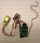
My Picaxe Lost Model Locator does not have GPS capability, the maths are a bit much. The FPU is a possibility but it aint cheap .....
So I set about producing an engine that I could use as a slave device to a PICAXE to allow the distance and direction between two waypoints to be calculated. The engine was written and tested in Mikrobasic on a 18F26K22, but it will (I mean should) fit in a 14 pin 16F1825. The purpose here is that the LML can report the distance and direction from the start location to its lost location as morse or telemetry.
To use the engine all you do is extract the 2 sets of Latttude and Longtitude text from a GPS string and send it to the engine via RS232 in this format (the engine sits there waiting for an AT to be received);
AT
5128.6970
N
00310.9570
W
5128.9620
N
00310.9140
W
The engine then replies with;
Distance 497M Direction 6D
Latitude1 = 5128.6970 N
Longtitude1 = 00310.9570 W
Latitude2 = 5128.9620 N
Longtitude2 = 00310.9140 W
La1 51.47828 Lo1 3.18262
La2 51.48270 Lo2 3.18190
Those are waypoints of the centre of the Millenium Stadium and the centre of Cardiff Castle keep. The (digital) OS map says its 493 Metres and 5 Degrees.
All I need now is a 16F1825 to try it out, about £1.20 from Farnell.
Is there general interest in the HEX code, all you need is a suitable PIC and a programmer ........
") !
!